London

Geraldine & Sarah
Arrival in London at Stanstead Airport

A visit to Google, DeepMind & Neil
IMG_0378 IMG_0407 IMG_0385 IMG_0386 IMG_0450 IMG_0382 IMG_0396 IMG_0394 IMG_0390 IMG_0392
<
>
Neil
St Pancras Station
IMG_0411 IMG_0416 IMG_0418 IMG_0422 IMG_1041
<
>
IMG_0421 IMG_0423 IMG_0374 IMG_1395
<
>

St Pancras railway station – Wikipedia

St Pancras railway station (/seɪnt ˈpæŋkrəs/ or /sənt ˈpæŋkrəs/), also known as London St Pancras and since 2007 as St Pancras International, is a central London railway terminus located on Euston Road in the London Borough of Camden.

Source: en.wikipedia.org/wiki/St_Pancras_railway_station

The British Library
IMG_0426 IMG_0435 IMG_0439 IMG_0436 IMG_0434 IMG_0687 IMG_0694 IMG_1052 IMG_1099
<
>
Leizer Ran
IMG_0427 IMG_0441 IMG_0442 IMG_0686 IMG_1076
<
>
Take a photo of your locker!

British Library – Wikipedia

Coordinates: 51°31′46″N 0°07′37″W / 51.52944°N 0.12694°W / 51.52944; -0.12694

Source: en.wikipedia.org/wiki/British_Library

On the Tube and the Trains
Hammersmith Station
IMG_0988 IMG_0503 IMG_0504 IMG_0680 IMG_0681 IMG_0684 IMG_0786 IMG_0789 IMG_1422 IMG_0814 IMG_0920 IMG_1114 IMG_1109 IMG_1133 IMG_1138 IMG_1409 IMG_1411
<
>
Flowers by Geraldine Auerbach
Memorial in Baker Street Tube

Meeting people
IMG_0513 IMG_0507 IMG_0670 IMG_0672 IMG_0673 IMG_0796 IMG_0799 IMG_0802 IMG_0805 IMG_0811 IMG_1118 IMG_1125 IMG_1344 IMG_1400 IMG_1418 IMG_1420 IMG_1225
<
>
Stefan, Sadler, Shoshana, Cecile & Daniel
The Wiener Library

IMG_0828 IMG_0820
<
>

Wiener Library for the Study of the Holocaust and Genocide – Wikipedia

The Wiener Library for the Study of the Holocaust and Genocide (German pronunciation: [ˈviːnɐ ]); is the world’s oldest institution devoted to the study of the Holocaust, its causes and legacies. Founded in 1933 as an information bureau that informed Jewish communities and governments worldwide about the persecution of the Jews under the Nazis, it was transformed into a research institute and public access library after the end of World War II and is now situated in Russell Square, London.[2]

Source: en.wikipedia.org/wiki/Wiener_Library_for_the_Study_of_the_Holocaust_and_Genocide

The West End
IMG_0853 IMG_0854 IMG_0857 IMG_0910 IMG_0913 IMG_0914 IMG_0917 IMG_0918
<
>
Hype Park Corner

West End of London – Wikipedia

The West End of London (commonly referred to as the West End) is an area of Central and West London in which many of the city’s major tourist attractions, shops, businesses, government buildings and entertainment venues, including West End theatres, are concentrated.

Source: en.wikipedia.org/wiki/West_End_of_London

Selfridges
IMG_0863 IMG_0867 IMG_0868 IMG_0870 IMG_0871 IMG_0872 IMG_0873 IMG_0877 IMG_0878 IMG_0911
<
>

Selfridges, Oxford Street – Wikipedia

Selfridges is a Grade II listed retail premises on Oxford Street in London. It was designed by Daniel Burnham for Harry Gordon Selfridge, and opened in 1909.[1] Still the headquarters of Selfridge & Co. department stores, with 540,000 square feet (50,000 m2) of selling space,[2] the store is the second largest retail premises in the UK,[1] half as big as the biggest department store in Europe, Harrods.[2] It was named the world’s best department store in 2010,[3] and again in 2012.[4]

Source: en.wikipedia.org/wiki/Selfridges,_Oxford_Street

Hammersmith
Natalie Rabinowitz
IMG_0922 IMG_0923 IMG_0933 IMG_0949 IMG_0979 IMG_0980
<
>
Natalie Rabinowitz
Westminster
IMG_1404 IMG_1408
<
>
Westminster Abbey
St Albans

First Bunnings in the UK. Bunnings was started in Perth, Australia. Ten minute walk from Neil

IMG_1260 IMG_1249 IMG_1247 IMG_1244 IMG_1243 IMG_1238 IMG_1230 DSC_5274 DSC_5281
<
>
Sausage Sizzle
Around the Nunnery
DSC_5373 DSC_5286 DSC_5287 DSC_5290 DSC_5437 DSC_5465 DSC_5466 DSC_5479 IMG_0780 IMG_0782
<
>
Go Fly A Kite
The Town
DSC_5293 DSC_5295 DSC_5297 DSC_5298 DSC_5299 DSC_5302 DSC_5303 DSC_5310 DSC_5315 DSC_5320 DSC_5322 DSC_5325 DSC_5329 DSC_5337 DSC_5340 DSC_5342 IMG_1334 DSC_5346 DSC_5354 DSC_5355 DSC_5359 DSC_5363 DSC_5370 IMG_0456 IMG_1219
<
>
Bicycle Rack at Station
Reading Material

Read the character names on these pages – amazing coincidence – Roly Poly Bird saves Jill! Roly Poly is what the grandkids call me!

IMG_1018 IMG_1027 IMG_1029
<
>

St Albans – Wikipedia

St Albans /sənt ˈɔːlbənz/, /seɪn … / is a city in Hertfordshire, England, and the major urban area in the City and District of St Albans. It lies east of Hemel Hempstead and west of Hatfield, about 19 miles (31 km) north-northwest of London, 8 miles (13 km) southwest of Welwyn Garden City and 11 miles (18 km) south-southeast of Luton. St Albans was the first major town on the old Roman road of Watling Street for travellers heading north, and it became the Roman city of Verulamium. It is a historic market town and is now a dormitory town within the London commuter belt and the Greater London Built-up Area.

Source: en.wikipedia.org/wiki/St_Albans

Back to Australia – Dubai
IMG_1508 IMG_1521
<
>
IMG_1519 IMG_1515
<
>
Flying somewhere!


St Albans England

Here are some photos taken last weekend at and around  St Albans, outside London.

DSC_3676 DSC_3678 DSC_3681 DSC_3682 DSC_3685 DSC_3686 DSC_3692 DSC_3694 DSC_3697 DSC_3705 DSC_3711 DSC_3721 DSC_3728 DSC_3731 IMG_6608 IMG_6607
<
>

St Albans

From Wikipedia, the free encyclopedia
St Albans
StAlbansCathedral-PS02.JPG
View of the west end of St Albans Abbey Church
St Albans COA.svg
Coat of Arms

St Albans is located in Hertfordshire

St Albans
St Albans
 St Albans shown within Hertfordshire
Area  6.99 sq mi (18.1 km2)
Population 57,795 (2011)[1]
   – density  8,268/sq mi (3,192/km2)
OS grid reference TL148073
   – London 19 mi (31 km)  SSE
District St Albans
Shire county Hertfordshire
Region East
Country England
Sovereign state United Kingdom
Post town ST. ALBANS
Postcode district AL1, AL2, AL3, AL4

Coordinates51.755°N 0.336°W

St Albans /sənt ˈɔːlbənz//sn…/ is a city in Hertfordshire, England and the major urban area in the City and District of St Albans. It lies east of Hemel Hempstead and west of Hatfield, about 19 miles (31 km) north-northwest of London, 8 miles (13 km) southwest of Welwyn Garden City and 11 miles (18 km) south-southeast of Luton. St Albans was the first major town on the old Roman road of Watling Street for travellers heading north, and it became the Roman city of Verulamium. It is a historic market town and is now a dormitory town within the London commuter belt and the Greater London Built-up Area.

Name

St Albans takes its name from the first British saint, Alban. The most elaborate version of his story, Bede’s Ecclesiastical History of the English People, relates that he lived in Verulamium, sometime during the 3rd or 4th century, when Christians were suffering persecution. Alban met a Christian priest fleeing from his persecutors and sheltered him in his house, where he became so impressed with the priest’s piety that he converted to Christianity. When the authorities searched Alban’s house, he put on the priest’s cloak and presented himself in place of his guest. Consequently, he was sentenced to endure the punishments that were to be inflicted upon the priest, unless he renounced Christianity. Alban refused and was taken for execution. In later legends, his head rolled downhill after execution and a well sprang up where it stopped.[2]

The Hertfordshire County Show

DSC_3877 DSC_4046 DSC_4039 DSC_4019 DSC_3987 DSC_3950 DSC_3948 DSC_3939 DSC_3922 DSC_3917 DSC_3910 DSC_3904 DSC_3902 DSC_3899 DSC_3884 DSC_3883
<
>

A Walk To Verulamium

IMG_6547 IMG_6594 IMG_6585 IMG_6583 IMG_6572 IMG_6557
<
>

Verulamium

From Wikipedia, the free encyclopedia

Coordinates51.7500°N 0.3539°W

Verulamium
Mortared wall with stacked thick stone layers over thin red brick layers, with a triangular tunnel through

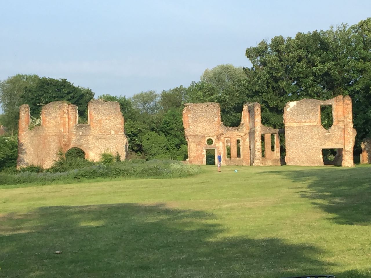
Remains of the city walls

Verulamium is located in Hertfordshire

Verulamium
Verulamium
 Verulamium shown within Hertfordshire

Verulamium was a town in Roman Britain. It was sited in the southwest of the modern city of St Albans in HertfordshireGreat Britain. A large portion of the Roman city remains unexcavated, being now park and agricultural land, though much has been built upon (see below).[1] The ancient Watling Street passed through the city. Much of the site and its environs is now classed as a scheduled ancient monument.[2]

History

Before the Romans established their settlement, there was already a tribal centre in the area which belonged to the Catuvellauni. This settlement is usually called Verlamion. The etymology is uncertain but the name has been reconstructed as *Uerulāmion, which would have a meaning like “[the tribe or settlement] of the broad hand” (Uerulāmos) in Brittonic.[3] In this pre-Roman form, it was among the first places in Britain recorded by name. The settlement was established by Tasciovanus, who minted coins there.

The Roman settlement was granted the rank of municipium around AD 50, meaning its citizens had what were known as “Latin Rights”, a lesser citizenship status than a colonia possessed. It grew to a significant town, and as such received the attentions of Boudica of the Iceni in 61, when Verulamium was sacked and burnt on her orders: a black ash layer has been recorded by archaeologists, thus confirming the Roman written record. It grew steadily; by the early 3rd century, it covered an area of about 125 acres (0.51 km2), behind a deep ditch and wall. It is the location of the martyrdom of the first British martyr saint, Saint Alban, who was a Roman patrician converted by the priest Amphibalus.[4]

Roman theatre packed-earth entryway and central stage surrounded by grass-covered seating hillocks (ruins)

Roman theatre

Verulamium contained a forumbasilica and a theatre, much of which were damaged during two fires, one in 155 and the other in around 250. One of the few extant Roman inscriptions in Britain is found on the remnants of the forum (see Verulamium Forum inscription). The town was rebuilt in stone rather than timber at least twice over the next 150 years. Occupation by the Romans ended between 400 and 450.

There are a few remains of the Roman city visible, such as parts of the city walls, a hypocaust still in situ under a mosaic floor, and the theatre, which is on land belonging to the Earl of Verulam, as well as items in the Museum (below). More remains under the nearby agricultural land which have never been excavated were for a while seriously threatened by deep ploughing.

Sub-Roman times

St Albans Abbey and the associated Anglo-Saxon settlement were founded on a hill outside the Roman city. The site of the abbey may have been a location where there was reason to believe that St Alban was executed or buried. More certainly, the abbey is near the site of a Roman cemetery, which, as was normal in Roman times, was outside the city walls. It is unknown whether there are Roman remains under the medieval abbey. An archaeological excavation in 1978, directed by Martin Biddle, failed to find Roman remains on the site of the medieval chapter house.[5]

David Nash Ford identifies the community as the Cair Mincip[6] (“Fort Municipium“) listed by Nennius among the 28 cities of Britain in his History of the Britains.[7] As late as the eighth century the Saxon inhabitants of St Albans nearby were aware of their ancient neighbour, which they knew alternatively as Verulamacæstir or, under what H. R. Loyn terms “their own hybrid”, Vaeclingscæstir, “the fortress of the followers of Wæcla”, possibly a pocket of British-speakers remaining separate in an increasingly Saxonised area.[8]

Loss and recovery

The city was quarried for building material for the construction of medieval St Albans; indeed, much of the Norman abbey was constructed from the remains of the Roman city, with Roman brick and stone visible. The modern city takes its name from Alban, either a citizen of Verulamium or a Roman soldier, who was condemned to death in the 3rd century for sheltering Amphibalus, a Christian. Alban was converted by him to Christianity, and by virtue of his death, Alban became the first British Christian martyr.

Since much of the modern city and its environs is built over Roman remains, it is still common to unearth Roman artefacts several miles away. A complete tile kiln was found in Park Street some six miles (10 km) from Verulamium in the 1970s, and there is a Roman mausoleum near Rothamsted Park five miles (8 km) away.

Within the walls of ancient Verulamium, the Elizabethan philosopher, essayist and statesman Sir Francis Bacon built a “refined small house” that was thoroughly described by the 17th century diarist John Aubrey. No trace of it is left, but Aubrey noted, “At Verulam is to be seen, in some few places, some remains of the wall of this Citie”.

Moreover, when Bacon was ennobled in 1618, he took the title Baron Verulam after Verulamium. The barony became extinct after he died without heirs in 1626.

This title was revived in 1790 for James Grimston, a Hertfordshire politician. He was later made Earl of Verulam, a title still held by his descendants.

Another stretch of Roman wall

Verulamium Museum

The Verulamium Museum is a sizeable museum run by the district council in Verulamium Park (adjacent to St Michael’s Church), which contains much information about the town, both as a Roman and Iron Age settlement, plus Roman history in general. The museum was established following the excavations carried out by Mortimer Wheeler and his wife, Tessa Wheeler, during the 1930s. It is noted for the large and colourful mosaics and many other artefacts, such as pottery, jewellery, tools and coins, from the Roman period. Many were found in formal excavations, but some, particularly a coffin still containing a male skeleton, were unearthed nearby during building work. It is considered one of the best museums of Roman history in the country and has won an architectural award for its striking domed entrance.


Back